Becán “Ravine formed by Water”
Named by Archeologists Karl Ruppert and John Denison in 1934 in Yukatek Maya after the unusual moat that surrounds the ancient city.
It can also be interpreted as “The Way of the Serpent” (“Be” means Camino or roadway; “Kan” means serpent) because of the moats waters that twist in irregular size and shape.
HISTORICAL NOTES
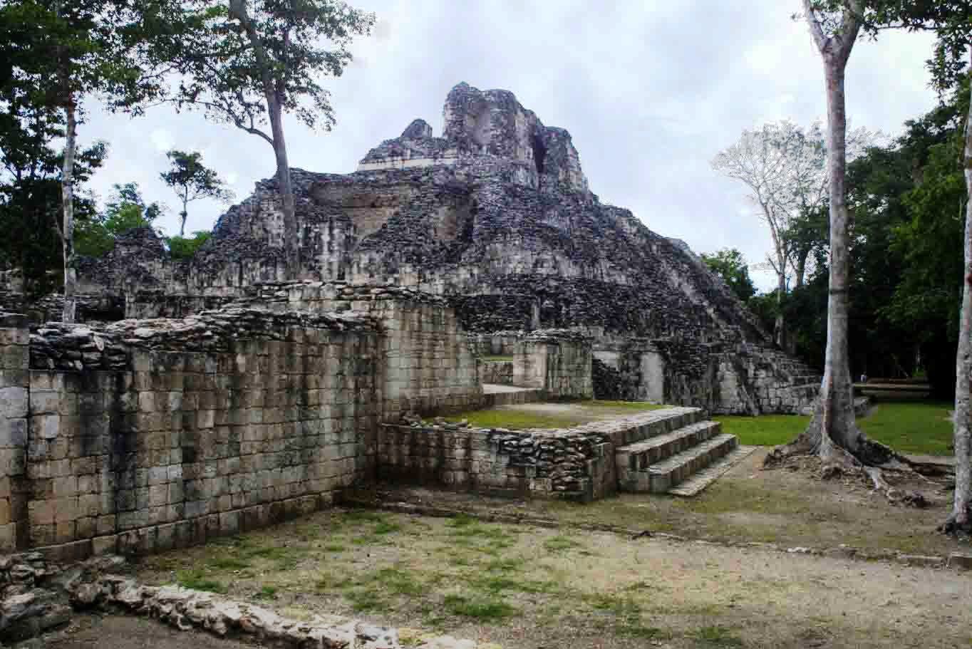
You can see Becán’s pyramids above the forest canopy from a fair distance.
Becán is a one of the Major Archeological site (of at least 45) that graces the base of the Yucatan Peninsula. It is by and large, unknown by the core tourist crowd, and youcan walk by yourself in the forest as you discover restored pyramids, grand plaza s and temples and palaces.
The fascinating moat, the only one as yet discovered in the Mayan world, was used as a fortification around the limestone structured City to head off potential problems with other trading and religious centers. It may also have been used to divide the elite from the common man. The area within the moat is the religious and ceremonial center.
Clay works and figurines from Teotihuacán provide links to trade and possible wars amongst Becán, Tikal and Teotihuacán. It was a major political and military center and is one of the many cities that fought against Tikal for dominance. Becán was Rio Bec’s political, religious and economic capital. (Becán, Channa, Chicanna, Okolhuitz, Puerto Roci, Ramonal and Xpuhil all belong to the Rio Bec grouping.)
Becán had a desirable location and was strategically located on number of trade routes between growing communities and cities; linking Campeche with Chetumal to the West/East and Tikal and the Peton area with the northern Chenes communities.

DATES
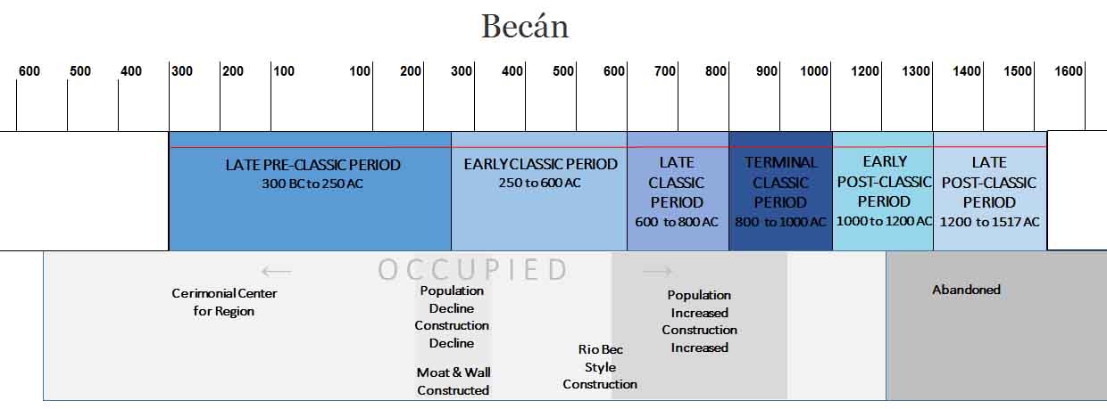
Occupation 550 BC
Grew to ceremonial center in 300 BC to 100 AD
Population and construction declined in 250 AD
Moat constructed
Construction in Rio Bec style began 500 AD
Peak 600 to 900 AD
Abandoned by 1200 AD
LOCATION & DESCRIPTION
Geographic location
Becán is located in Mexico on the Yucatan Peninsula just off Highway 186 between the present cities of Campeche and Chetumal in the State of Campeche. The site is 25 hectares (61.7 acres) in area.
Located in the protected Calakmul Biosphere Reserve, an amazing tropical forest connecting dry jungles to the north with rainy dense jungles of the Petén region, of Guatemala. The reserve is a refuge for many of Mexico’s endangered animal species. Be on the lookout for pumas and jaguar as well as wild turkeys, toucans and parrots.
Style
Becán has over 680 structures of which only a handful have been explored or restored.
Their architectural style is called Río Bec and is typical of other ruins in the region. It combines the styles of the Petén region, of Guatemala with Chenes from central Campeche. Stone blocks were cut to size and then covered afterwards with layer of stucco;
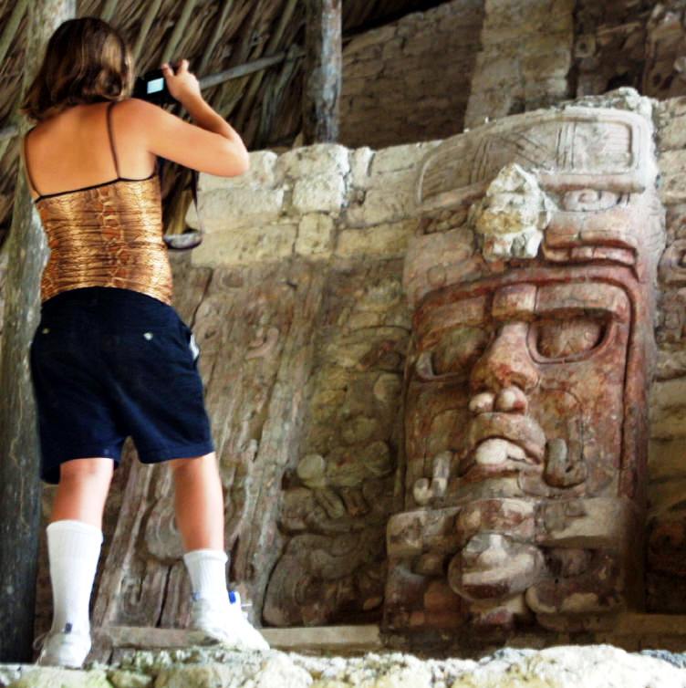
Look for Río Bec characteristics; thick walls, high twin towers, false stairways and temples, walls with rounded corners, wide interior benches, giant stucco and limestone masks of unknown beasts and those representing the earth god Itzamná
Monumental and awe inspiring.
Becán was believed to be deigned as a military stronghold using many of these elements. Certainly the false stairways and tunnels, dead ended passageways would completely confuse an enemy. The City is characterized by large plazas surrounded by monumental structures indicating its importance in the region. Becán also shows signs of the Chenes influence with detailed masks of the Itzamna god, also called the Earth Monster.
Enjoy your visit and please write us with any updates, corrections and comments.
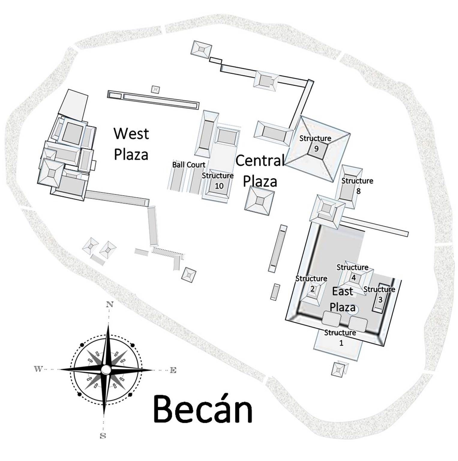
Map
Entrance
Tickets, parking, washrooms. Sale of some publications. First Aid. Satellite phone. There are explanatory signs throughout the site.
MAJOR GROUPINGS & STRUCTURE DESCRIPTIONS
Moat & Wall
The moat was excavated in the late pre-Classic between 100 and 250 A.D. Becán’s moat surrounding the ceremonial city is the only one in the Mayan world. The defensive wall is one of three within this ancient culture.
The moat is not without controversy. Some believe this was a defensive feature, a fortification, in much the same way a moat is used in medieval Europe. They believe it was used to protect itself from warring cities or competitive trading and religious centers.
Others believe that it was merely a clear physical separation and perhaps protection of the ceremonial and elite residential areas from the peasant class. Outside the walls and moat are a number of much more humble dwellings. The minor buildings were used to support the elite; farming structures, grain storage, residential living quarters and tiny temples. The elite would have access to the central core within the moat; ruling families, high level officials and the priestly class.
Early anthropologists Karl Ruppert and John Denison questioned if the moat was ever completed or used, noting that it had porous limestone sides and would not hold water. Yet they also acknowledge that north of the city there was a lake that could have very likely provided water for the waterway. The lakes have since dried up and only a bajo or swampland remains.
Another theory is that the moat is part of a water management system used to collect rainwater and prevent flooding.
Regardless od the purpose, the moat is five meters deep, sixteen meters wide and almost 1730 meters long as it makes its way around the kidney shaped ceremonial center. Seven bridges lead to entrances to the city. The east entrance is the current entrance to the site.
The 126,000 cubic meters (4.4 million cubic feet) of rock and soil created by the excavation were used to build monuments in the city as well as the defensive wall. The adjoining limestone wall is 3 to 4 meters (11 ft) tall in some places.
East Plaza
Structures I, II, III, IV and the Circular Altar
Structure 1
Structure 1 was constructed in the Becan’s infancy and has been continually modified and improved over the centuries. It is noted for the 15 meter twin towers and vaulted chambers. It is believed that some of these rooms were used to as observatories to record and interpret the stars and planetary movements. Other rooms are believed to have been used for religious purposes such as bloodletting, sacrificing to the Gods, or other religious ceremonies.
Structure 2
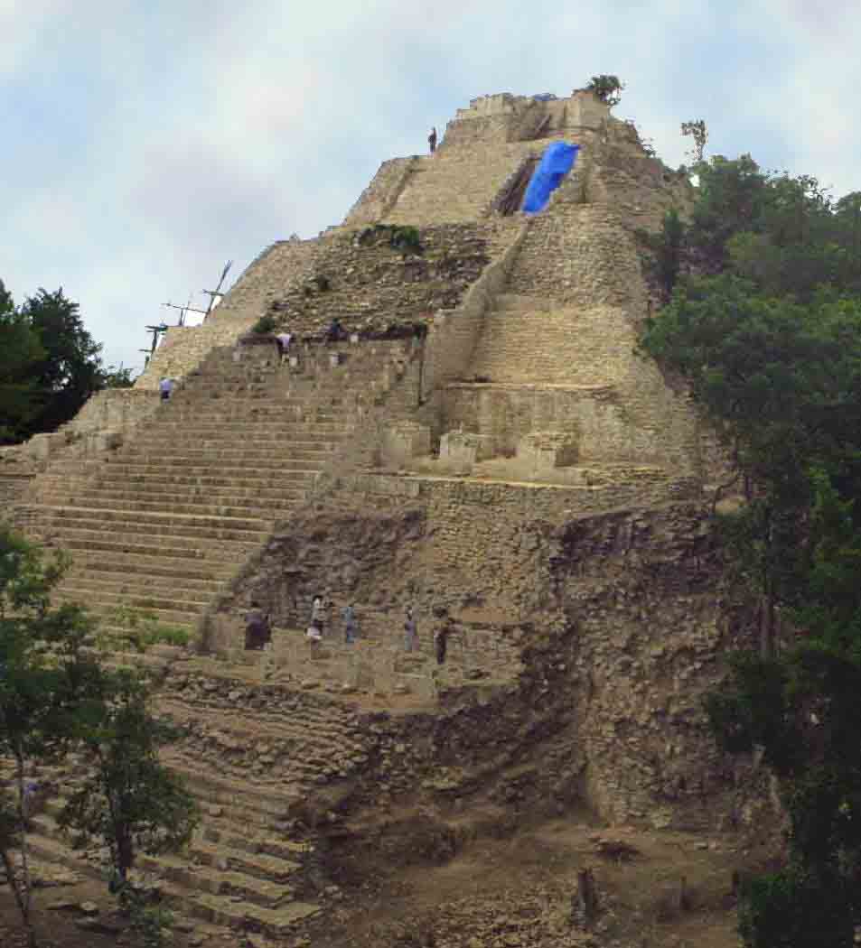
The great pyramid needs some repairs! 43 meters square and 14 meters high must have been a grand building with chambers on 3 of its sides. It is believed the chambers were for elite residents in the city.
Look for high and bas reliefs on the highly artistic decorated façade. There is a “checkerboard: and a stone cross. Judging from the amount of rubble originally found at the base, it is assumed there was once a temple on the top.
Rising from the base of the terrace on the west side is a 16 meter staircase. Close to it is a parallel mound thought once to be part of a ball court. Examination thus far has proven this incorrect.
Structure 3
Structure 3 is a long mound located on the eastern side of the East Plaza. It is 52 meters in length and 4.5 meters high and has an attached 6 meter square platform presumably for performances and events. It has many rooms including a stem bath.
Structure 4
This is a favorite to climb and explore; the view from the top of the pyramid is fantastic.
The 34 meter square pyramid has a steep central 17 meter staircase leading to a labyrinth of passages and rooms. Look for remains of a large monster mask. The front contains a court surrounded on three sides by chambers – an unusual style for the Rio Bec but is similar to an arrangement at Calakmul and Tikal the major cities to the south.
The rooms are generally well defined albeit crumbling walls. Often benches surround the rooms – usually used for sleeping.
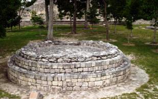
Circular Altar
There is a circular altar in the plaza closest to Structure One. It is built with blocks in two levels. It is a later addition to the plaza, dated at about 1200 CE.
Central Plaza
Structures 8, 9, 10
Plaza and pyramids likely used for ceremonial purposes and potentially as watchtowers. Contain Becan’s largest structures
Structure 8
Structure 8 is built on one level with a broad set of stairs leading to an entrance with a now ruined monster mask. It has twin towers and a decorative façade. It is connected to the East Plaza through a Mayan Arch.
Structure 9
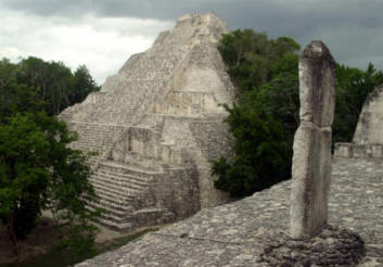
Structure 9 is 32 meters high and is the tallest building at the site. Crowning the pyramid is a beautiful temple on the top. Its spectacular panoramas are supposed to view across the jungle canopies all the way to Calakmul.
Structure 9 forms the northern side of the Central plaza.
Structure 10
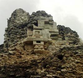
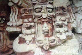
Structure 10 is an elaborate two level complex composed of 12 chambers; many with traces of original red and blue pigment on the walls. A temple was built on an upper level with a mask of Itzmna, the Creator God known also as the Earth Monster– whose mouth is the entrance doorway. You can also see the remains of a roof comb on top.
A mask of Sun God Kinichna – protected by glass – is also situated on Structure. The detail is stunning with well defined features and traces of red pigment paint.
Structure 11 – The Ball Court
Becán has a well preserved ball court consisting of 2 parallel buildings 32 meters long and an inner 9 meter wide courtyard or field of play. There is no evidence of stone rings such as those found at the Grande Ball Court in Chichén Itza. That does not mean rings were not used; only that permanent stone rings were not. Additionally no stone disks or end-markers were found at the end zone area of the court.
Structure 12
Located on the northwest of the Central Plaza. The building is unremarkable except that two stelae were found here. Neither were sculpted. Usually stelae indicate an important personage or event. Only Stelae 1 remains standing.
The West Plaza
Structure 13 complex forms the west side of the plaza, the Ball Court and Building 10 to the East.
A large horizontal mound frames the northern border and similarily to the south, a horizontal mound projects from the complex of Structure 13.
Structure 13
Structure 13 is a grand complex that has not been restored. Little has been studied or examined since Rupert disrcribed the site in 1934. The complex is in poor condition with only a few standing walls. It contains courts, pyramids, walls, valts and mounds. Archeologists have divided it into the South Court, the Middle Court, the North Court, and the Great Pyramid – all in a shambles with only traces of their former glory.
HOURS
Open Daily from 8 am to 5 pm. There is a watchman at the gate who will charge you the standard fee & extra for video cameras.
Admission 2013 46 pesos. Free on Sundays for nationals and Mexican residents.
Allow at least 2 to 3 hours, especially if you like to climb. More if you ike to read each plaque and take pictures.
RECOMMENDATIONS
You can stroll safely undisturbed throughout the site – often you will be the only ones there. Take good shoes as there is plenty of climbing- and a fair amount memory and batteries for your photographs. We recommend you stay on the designated paths as you can easily get lost in the dense bush jungle.
As this is site is in a somewhat remote jungle area, take water and insect repellant. There are no restaurants or food vendors.
Dress according to the season you are visiting.
GETTING THERE
GPS – N 18*31.023 W 089*27.860
Busses
Take a bus to Xpujil bus station and take a taxi to Becán.
Tours
Tours and tour buses go infrequently to Becán and generally make a combination package of sites along Highway 186
Drive from Villahermosa:
Take Highway 186 to Escárcega and then East to KM 146. Turn at signs. Take first left; then first right and then first left. to entrance. All well signed. Approximately 4 hours.
Drive from Campeche:
Drive Highway 180 South to Champotón. Turn to Highway 261 to Escárcega. Turn on Highway 186 towards Chetumal and drive to KM 146. Turn at signs. Take first left; then first right and then first left. to entrance. All well signed. Approximately 3 1/2 hours.
Drive from Chetumal:
Drive Highway 186 East towards Escárcega but turn at KM 146. Approximately 2 1/2 hours.