Cempoala Ruins
“Place of Twenty Waters”
in Nahuatl Cēmpoalli /twenty, ā tl /water
The city had numerous aqueducts to supply irrigation ditches for the farmland
Also known as or Zempoala
HISTORICAL NOTES
Cempoala was the most important Totonac city in Mexico. (The Totonac people populated the southern Coast of the Gulf of Mexico.) The Totonac had an n estimated population of 250,000 people and many populating 50 towns. Cempoala was the capital of these people and at its peak if had a population of over 25,000 people.
All the Totonac towns and cities were defeated by Montezuma’s armies around 1458 AD. The Aztecs treated them inhumanely and many of the Totonac ended up as slaves or sacrificial prisoners. As a tax – a tribute – the Totonac were forced to give food, goods and people.
The situation remained intolerable and when the Spanish arrived in 1519, twenty Cempoala dignitaries met with Cortez and took him to meet their leader “Fat Chief, Xicomecoatl”. It was the first Mexican City visited by Europeans. After presenting Cortez with gifts of feathers, gold, food, Xicomecoatl told Cortez about Moctezuma and the inhumane treatment. Soon after, Cortez and the Totonacs forged an alliance and together in August 1519 set forth with for the Aztec capital of Tenochtitlan. Cortez now had 40 Totonac and 200 porters to confront the Aztecs.
Cortez and his alliance army defeated Tenochtitlan and took captive the Aztec ruler Moctezuma and the conquest of Mexico began. After the victory the Cempoala Totonacs were banned from practicing their religion. They were relocated, Christianized and then forced into slavery. In 1575 a smallpox epidemic ravished Cempoala and the city was entirely abandoned.
DATES
Timeline Graph
Specific dates
Evidence of Olmec influence
1000-1150 AD The Totonacs moved to the coastal plain having been pushed by the Toltecs from their Sierra Madre settlements in the interior.
1300 to 1500 Major buildings constructed.
1458 Cempoala and the other Totonac towns and cities were defeated by Montezuma’s Armies
1519 Meeting with Cortez and alliance developed. Cemoala army joins with Cortez to set forth to the Capital of the Aztec Empire Tenochtitlan
1575 Smallpox decimated the population and the city was deserted.
LOCATION & DESCRIPTION
Geographic location
Cempoala is situated on a flat coastal plain on the Gulf Coast of Mexico in what is now called the State of Veracruz. It is about a kilometer from the Rio Actopan River, 6 kilometers west of the Gulf of Mexico and 49 kilometers north of the City of Veracruz.
Map – Coming Soon
Entrance
Tickets, washrooms, site museum
MAJOR GROUPINGS & STRUCTURE DESCRIPTIONS
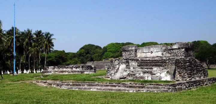
Cempoala was a large complex of ceremonial buildings as well as those that are beyond the walls of the present archeological site. It was surrounded by aqueducts that provided domestic water to the ceremonial center, residences and to the farmlands for irrigation.
Built on swampy land, the buildings were built on platforms elevating them above the flood levels. The ceremonial and urban core was 120,000 meters (1,292,00o square feet) with much more outside that area.
The main structures are:
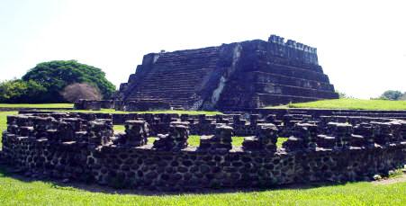
The Great Pyramid
The Great Pyramid is the largest structure on the site. Resembling the Pyramid of the Sun in Teotihuacan and is sometimes called the Sun Temple.
Templo Mayor
Templo de las Chimeneas
Named after the 1.5 meter high semicircular pillars
El Pimiento Compound
Decorated with skulls
Montezuma’s Palace
Templo de la Cruz
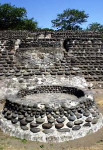
Rings
The three rings were astronomical tools used to calibrate time and cycles of the Sun and planets.
HOURS
Open Daily from 8 am to 5 pm. Allow 1 ½ hours.
RECOMMENDATIONS
You can stroll safely undisturbed throughout the site. It is generally not very crowded. Take good shoes for walking and a fair amount memory and batteries for your photographs. There are no vendors inside the ceremonial site so carry water.
GETTING THERE
GPS – N19.26.42 W 96.24.32
Bus:
You can catch busses from Veracruz or Xalapa to Jose Cardel. From there you catch local buses. Remember Cempoala is often spelled Zempoala
Tours:
Tours and tour buses go frequently to Cempoala from Veracruz and often combine tours with Quiahuiztlan, an old Totonaca city located on Metates Hill and La Antigua and the home of Hernando Cortez.
Drive from Veracruz City:
Take Highway 180 North towards and past José Cardel to Cempoala (approximately KM 35. Clear signage to the Archeological site.