Xpujil
“Cat’s Tail”
Named after a pond in the area. In Mayan Xpuhil is a wild plant Jack Cola.
The nearby town named itself after the site albeit with different spelling.
Karl Ruppert and John Denison rediscovered the ruins in 1930 when the site was in much better condition than it is now in.
HISTORICAL NOTES
Likely a subordinate community for Becán, Xpujil has enjoyed a long period of occupation. Archeological evidence shows that Xpujil was populated as early as 300 BC in the Preclassic Period. Most of the buildings were constructed between 600 and 800 AD in the Late Classic period when the central ceremonial core with residential buildings for the city’s elite were built.
The site was abandoned shortly after 1200 AD. As with many ancient sites the exact reason is not known.
It was rediscovered in 1938.
DATES
Occupied 300 BC
Peak 600 to 800 AD
Declined 1200 AD
Timeline Graph
LOCATION & DESCRIPTION
Geographic Location
Xpijil is located in Mexico on the Yucatan Peninsula just off Highway 186 between the present cities of Campeche and Chetumal in the State of Campeche. The site is approximately 5 square acres.
Located in the protected Calakmul Biosphere Reserve, an amazing tropical forest connecting dry jungles to the north with rainy dense jungles of the Petén region, of Guatemala. The reserve is a refuge for many of Mexico’s endangered animal species. Be on the lookout for pumas and jaguar as well as wild turkeys, toucans and parrots.
Map
Entrance
Satellite phone, explanatory and Interpretive signs. Parking, publications, first aid and watchman.
MAJOR GROUPINGS & STRUCTURE DESCRIPTIONS
Style
Xpujil composed of about 17 architectural groups however on a few have been restored.
The architectural style is called Río Bec and is typical of other ruins in the region. It combines the styles of the Petén region, of Guatemala with Chenes from central Campeche. Stone blocks were cut to size and then covered afterwards with layer of stucco. Structure one is an exception to the Rio Bec style.
Enjoy your visit and please write us with any updates, corrections and comments.
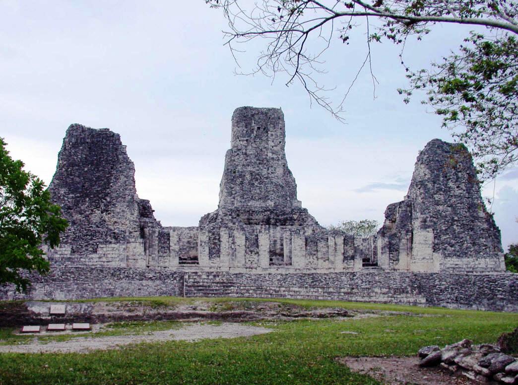
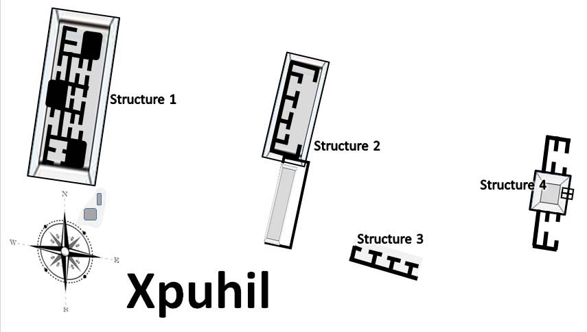
Structure 1
Also known as Building of the Three Towers, Structure 1 is unusual in the region and for Rio Bec architecture because of that middle third tower; the only example anywhere. The three towers are grouped together on a large platform 53 meters long by 26 wide and 2 meters high with an east facing 18 meter wide stairwell.
The central tower is 18 meters high and has 12 rooms oriented to the four cardinal points. La fachada principal se encuentra en el lado oriente, hacia donde miran dos de las tres torres del inmueble entre las cuales hay tres entradas al edificio que están flanqueadas por cascadas de mascarones en bajorrelieve sobre las que se aprecian portadas zoomorfas parciales.It faces East – the most important direction for Mesoamerican cultures.
The towers had extremely steep staiways, false staiwells, doorways leading nowhere and false temples. The purpose was to awe .Look for Earth Monster masks on the temple doors.
Structure 2
Located to the east of the Tree Towers Building, Structure 2 has a façade, small rooms and a false arch.
Structure 3
Structure III appears to be a residential building because of the benched inside.
Structure 4
La Estructura I, también conocida como el Edificio de las Tres Torres, se desplanta sobre una plataforma de esquinas redondeadas que mide 53 metros de largo por 26 de ancho y 2 de altura, a la cual se asciende por medio de una escalinata de 18 metros de ancho en lado oriente.Justo al oriente de la I se localiza la Estructura II, sobre cuya fachada existen los cimientos de pequeños cuartos que alguna vez estuvieron techados con arco falso.La Estructura IV tiene dos niveles con aposentos también de carácter habitacional; sus banquetas están decoradas con motivos cruciformes, o bien adoptando forma de T, elemento que simboliza al viento, haciendo alusión al “aliento de vida”.Structure IV is comprised of two levels of residential apartments. It is also decorated with a T shaped elements symbolizing the wind, called the “breath of life”.
HOURS
Open 8-5. There is a watchman at the gate who will charge you the standard fee & extra for video cameras.
Admission 46 pesos. Free on Sundays for nationals and Mexican residents.
Allow at least 1 to 2 hours, especially if you like to climb.
RECOMMENDATIONS
You can stroll safely undisturbed throughout the site – often you will be the only ones there. Take good shoes as there is plenty of climbing- and a fair amount memory and batteries for your photographs. We recommend you stay on the designated paths.
As this is site is in a jungle area, take water and insect repellant. There are no restaurants or food vendors at the site and you must go to the town for refreshments.
Dress according to the season you are visiting.
GETTING THERE
GPS – N 18.30.38 W 89.24.21
Busses
Take a bus to Xpujil bus station. Site is on the West side of town. Walk from there.
Tours
Tour Buses infrequently go to Xpuhil and generally make a combination package of sites along Highway 186
Drive from Villahermosa:
Take Highway 186 to Escárcega and then East to KM 156. Turn at signs. All well signed. Approximately 4 hours.
From Campeche:
Drive Highway 180 South to Champotón. Turn to Highway 261 to Escárcega. Turn on Highway 186 towards Chetumal and drive to KM 156. Turn at signs. All well signed. Approximately 3 1/2 hours.
From Chetumal:
Drive Highway 186 East towards Escárcega but turn at KM 156. Approximately 2 1/2 hours.